Preview
Creation Date
3-18-1923
Description
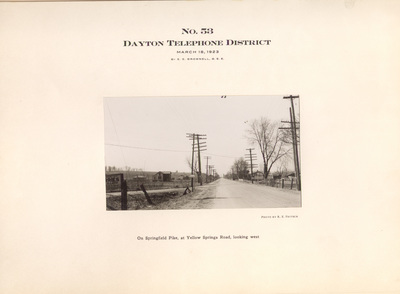
Street scene photograph showing the location of Dayton area telephone poles and telephone lines. Photograph No. 53, On Springfield Pike, at Yellow Springs Road (later Northcliff Drive), looking west. In addition to the telephone pole lines, the photograph shows: a rural area in Mad River Township, including residences, barns, farm buildings, and fields. A sign identifying the "Village of Harries" is partially visible at the left foreground.
Source
"Photographs of Telephone Pole Lines of The Ohio Bell Telephone Company Dayton District" by E.E. Brownell (March 1923)
Item Identifier
ms70_02_055
Publisher Repository
Special Collections and Archives; Wright State University Libraries
Permissions
Special Collections and Archives provides reprints or digital copies of our materials for a fee. For further information please visit their website or call (937) 775-2092.
Collection
MS-70: Dayton Telephone Pole Line Photographs
Media Type
Photographic print, black and white
Spatial Coverage
Mad River (Montgomery County, Ohio : Township); Riverside (Ohio); Harries (Ohio)
Repository Citation
Fritsch, R. E., "No. 53, On Springfield Pike, at Yellow Springs Road, Looking West" (1923). Dayton Telephone Pole Line Photographs (MS-70). 53.
https://corescholar.libraries.wright.edu/special_ms70_photographs/53
Keywords
Springfield Pike; Yellow Springs Road; Northcliff Drive; Mad River (Montgomery County, Ohio : Township); Riverside (Ohio); Harries (Ohio); Streets--Ohio--Riverside; Houses; Farms
Image Location
Rights Statement