
Preview
Item Identifier Number
PeaceAgreement_1995_11_21_034
Creation Date
11-21-1995
Collection
MS-458: Dayton Daily News Archive
Description
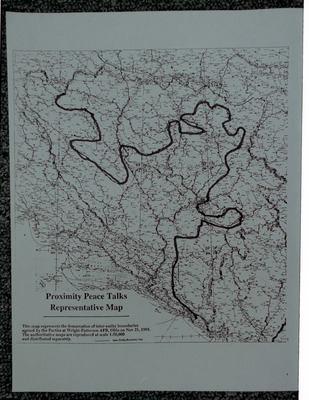
A map showing the Inter-Entity Boundary Line, the political division of Bosnia and Herzegovina into the Republika Srpska to the north-east of the line and the Federation of Bosnia and Herzegovina to the south-west.
The caption on the map reads: This map represents the demarcation of inter-entity boundaries agreed by the Parties at Wright-Patterson AFB, Ohio on Nov 21, 1995. The authoritative maps are reproduced at scale 1:50,000 and distributed separately.
Publisher Repository
Special Collections and Archives; Wright State University Libraries
Digital Publisher
Special Collections and Archives; Wright State University Libraries
Document Type
Image
Media Type
negative
Permissions
Special Collections and Archives provides reprints or digital copies of our materials for a fee. For further information please visit our website or call (937) 775-2092.
Date Digital
October 2024
Keywords
MS-458_NGP_Underwood_05; PeaceAgreement_1995_11_21_034; Dayton Daily News; Dayton Peace Accords (1995)--Maps; Yugoslav War, 1991-1995--Bosnia and Herzegovina; Yugoslav War, 1991-1995 -- Peace; Bosnia and Herzegovina; Partition, Territorial--Maps; Sarajevo Metropolitan Area (Bosnia and Herzegovina)--Administrative and political divisions--Maps; Bosnia and Herzegovina--Administrative and political divisions--Maps; Bosnia and Herzegovina--History--Partition, 1995--Maps
